
2023 Adventure Trails Map
 This printed map published by Discovery Routes includes 350km of the Voyageur Cycling Route across Northeastern Ontario.
Also Featuring:
53 Hike and Snowshoe Trails; 6 Cross-Country Ski Trail Networks; 20 Bicycle Touring Routes including Gravel road rides, Mountain Bike and Fat Bike trails, and our new Old Nipissing Ghost Road Bikepacking route16 Recommended Paddling Routes for day-trips and overnight backcountry trips with details on access points and portages
Map Geography: Almaguin Highlands, Loring/ Restoule, North Bay to Mattawa, West Nipissing, Sudbury East
Discovery Routes is selling the 2023 Adventure Trails Map for $10 plus shipping ($2.50) as a fundraiser to support our charitable activities in trail development and advocacy.
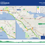
Voyageur Cycling Route Self-Guided Experiences
Discovery Routes has created a number of self-guided bike tours along the Voyageur Cycling Route. Each Cycling Experience has a customized Google Map and links to available digital maps through apps such as MapMyRide, Trailforks and Ride With GPS.
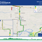
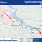
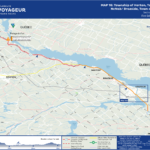
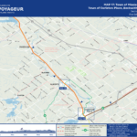
Voyageur Cycling Route Downloadable Maps
The Voyageur Cycling Route is part of the foundational province-wide cycling network with direct connections to the Great Lakes Waterfront Trail, the Georgian Bay Cycling Route, the National Capital Region and La Route Verte.
These cycling route maps complement the more than 645 km of trail and roadway designated as the Voyageur Cycling Route, including interim routing along sections of roadway where the trail is not yet open or suitable for cyclists.
Each map outlines a section ranging from 18 to 50 kilometers. Maps will updated from time to time to better reflect the current status of the cycling route.

** NOT ALL OF THE PREFERRED VOYAGEUR CYCLING ROUTE HAS CYCLING INFRASTRUCTURE IN PLACE. **
Maps for Download:
-
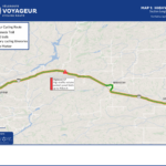
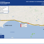
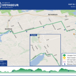
- Map 1: Hwy 17 Markstay-Warren

-
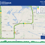
- Map 2: Hwy 64 St Charles

-
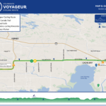
- Map 3: Hwy 64 Noelville

-

- Map 4: Hwy 64 Mashkinonje & Lavigne

-
- Map 5: Hwy 64 Cache Bay

-

- Map 6: Hwy 17 Sturgeon Falls

-
- Map 7: Hwy 17 Nipissing First Nation

-
- Map 8: North Bay

-
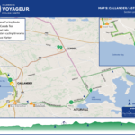
- Map 9: Callander Astorville

-
- Map 10: Bonfield

-

- Map 11: Mattawa

-

- Map 12: Hwy 17 Head, Clara & Maria

-

- Map 13: Hwy 17 Deep River

-
- Map 14: Petawawa, Pembroke

-

- Map 15: Whitewater

-
- Map 16: Arnprior, McNab/Braeside

-
- Map 17: Mississippi Mills, Carleton Place

-

- Map 18: Ottawa TBA